Archaeological Investigation of the Northwest Corner of Bruton Parish's First Brick Church: Preliminary Report
Colonial Williamsburg Foundation Library Research Report Series - 1715
Colonial Williamsburg Foundation Library
Williamsburg, Virginia
2010
Archaeological Investigation of the Northwest Corner of Bruton Parish's First Brick Church: Preliminary Report
Principal Investigator
Marley R. Brown III
Colonial Williamsburg Foundation
Department of Archaeological Research
November 1992
Re-issued
April 2001
Acknowledgments
The following staff participated in the project: Marley R. Brown III directed the project, Andrew Edwards and David Muraca supervised the excavations, Kimberly Wagner and Jennifer Jones were responsible for the detailed drawings, John Metz, Cara Metz, Audrey Horning-Kossler, and Elizabeth Anderson served as highly skilled field technicians. The artifacts were identified and processed by Pegeen McLaughlin-Pullins under the direction of William E. Pittman. Corey Judson, Laura Croghan, Michael Bradshaw, and Marie Blake greatly facilitated the excavation process by volunteering their respective skills. Carl Lounsbury, Henry Miller, Alain Outlaw, and Norman Barka served as consultants and independent observers. Michael Durling of Colonial Williamsburg Productions video-taped the project daily, while associates Dave Doody and Tom Green shot still photographs.
The Rector of Bruton Parish Church, the Reverend Richard May, and church administrator Paul Parsons were nearly always at the site, virtually setting up their offices in the graveyard in order to answer questions from the on-lookers and press. The Bruton Parish interpreters are also to be commended for their handling of the especially large crowds.
The authors would also like to extend their thanks to Patrick Milliman and Ken Kipps of Colonial Williamsburg's media relations department for their help in handling the press releases and coordinating press, church, and archaeology. A special thanks also is extended to Terry Yemm and his landscape crew to whom it befell the onerous task of backfilling the site after the excitement was over.
After the archaeological excavations were completed, Professor Gerald Johnson of William & Mary's Geology Department hand-augered 12 four-inch holes in the excavation unit to a depth of over 20 feet. The purpose of the augering was to determine whether the so-called "Bacon's Vault" could have been placed below the excavation area via tunnels, without disturbing the ground. Dr. Johnson will submit a separate report to the Bruton Parish vestry describing the results of his augering.
Table of Contents
| Page | |
| Acknowledgments | i |
| List of Figures | iii |
| Introduction | 1 |
| Research Plan | 1 |
| Previous Excavations | 4 |
| Archaeological Methods and Procedures | 7 |
| Historic Context | 10 |
| Excavation Process | 12 |
| Conclusions | 19 |
| References | 22 |
| Appendix 1. Artifact Inventory | 23 |
List of Figures
| Page | |
| Figure 1. Historic Area, Colonial Williamsburg, showing location of site | 2 |
| Figure 2. St. Luke's Church, Isle of Wight County, Virginia. | 2 |
| Figure 3. Plan of First Brick Church, from Michel 1702 | 3 |
| Figure 4. Area excavated prior to 1992 | 5 |
| Figure 5. Northwest corner of First Brick Church, 1938 | 5 |
| Figure 6. 1992 excavation area | 8 |
| Figure 7. Harris matrix diagram | 8 |
| Figure 8. Excavation in progress | 12 |
| Figure 9. Harris matrix | 13 |
| Figure 10. Unmarked graves found within excavation area | 14 |
| Figure 11. Section drawing of Grave 2 | 15 |
| Figure 12. Section drawing of Grave 1 | 16 |
| Figure 13. Details of eighteenth-century coffin | 17 |
| Figure 14. Dr. Gerald Johnson taking an auger sample | 18 |
Introduction
Research Plan
In the fall of 1991 Colonial Williamsburg's Department of Archaeological Research was approached by the vestry of Bruton Parish Episcopal Church to provide a research plan for the partial excavation of the First Brick Church of Bruton Parish, the foundations of which were located in the present churchyard. In July of 1992 the vestry accepted Colonial Williamsburg's proposal submitted by D.A.R. director Marley R. Brown III.
The Department of Archaeological Research proposed to undertake an investigation of a portion of the foundations of the First Brick Church and also attempt to determine the cause of remote sensing anomalies located in the northwest corner of the foundations (Figure 1). The two anomalies had been reported by geophysisists in 1938 and 1985. Although the basic plan of the church was revealed during the 1938 excavations, little is known about the above-ground appearance of the structure except what can be extrapolated from contemporary churches. Constructed between 1681 and 1684, the church was, according to CWF architectural historian Carl Lounsbury, similar in size, appearance, and plan to St. Luke's Church, Newport Parish, Isle of Wight, Virginia, the only standing seventeenth-century church in the state, also built in the 1680's (Figure 2). Both buildings were rectangular with no separate sections for nave and chancel, similar to post-Reformation Anglican churches St. Ninean in Brougham, Cumbria, and St. Saviour in Foremark, Derbyshire, built in 1660 and 1662, respectively (Lounsbury 1991).
A Swiss traveller, Franz Ludwig Michel, made a sketch of Bruton's First Brick Church in 1702. Unfortunately, this unique rendering of the church is quite inaccurate. Michel failed to draw any of the buttresses and depicts but three of the five bays known to exist. Michel's drawing shows only the front door to the church, but it probably had two entrances, the main one on the west end for the congregation, and another on the south side, near the east end for the priest (Figure 3). While any conclusions drawn from the Michel drawing are obviously suspect, it does provide some useful information. The two windows shown over the entrance may indicate, according to Lounsbury, the presence of a gallery, an architectural feature that archaeology hoped to confirm. Michel's drawing also shows curvilinear gables on either end of the building, again like those found on St. Luke's and at Bacon's Castle, a contemporary brick house in Surry County, Virginia. Unlike St. Luke's and the seventeenth-century church ruins at Jamestown, Bruton Parish's church does not appear to have had a tower, and one is not shown in Michel's drawing. (The vestry did entertain the idea, however, in 1684, but obviously decided against the addition [McCabe 1856].)
Molded water table and mullion brick found during the excavation of a contemporary chapel at St. Mary's City, Maryland helped archaeologists and architectural historians learn a great deal about the above-ground appearance of that building. Recovering similar brick from the Bruton Parish excavations may have provided analagous information about
2
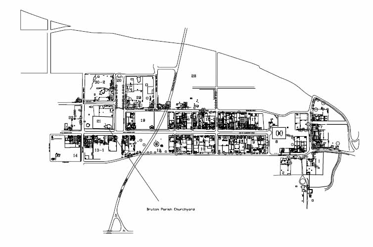 Figure 1. Historic Area, Colonial Williamsburg, showing location of site.
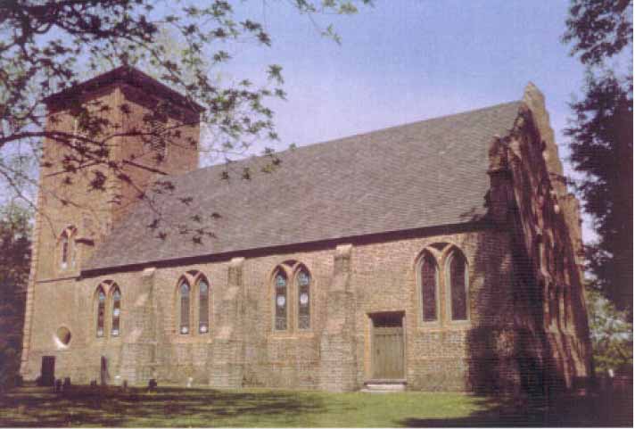 Figure 2. St. Luke's Church, Isle of Wight County, Virginia.
3
Figure 2. St. Luke's Church, Isle of Wight County, Virginia.
3
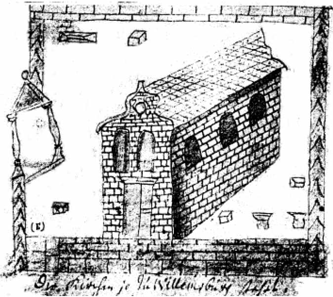 Figure 3. Plan of First Brick Church, from Michel 1702.
the First Brick Church. Expected finds also included similar molded bricks or mortar from the curvilinear gable treatments, and bits of window glass which could be pieced together, possibly determining the types of panes used.
Figure 3. Plan of First Brick Church, from Michel 1702.
the First Brick Church. Expected finds also included similar molded bricks or mortar from the curvilinear gable treatments, and bits of window glass which could be pieced together, possibly determining the types of panes used.
Archaeology could help architectural historians determine whether the floor in the church was brick tile, stone, or wood by unearthing part of the floor or fragments of any paving material. Such information would be invaluable in constructing a more accurate picture of rare seventeenth-century ecclesiastical structures.
The Department of Archaeological Research proposal also provided for an investigation of the anomaly revealed by soil resistivity tests at the Bruton Parish churchyard in 1986. These tests were conducted by Bruce Bevan, an experienced geophysical surveyor who has frequently consulted with archaeologists in the region. Bevan concluded in 1986 that there was an anomaly in the churchyard near the northwest corner of the First Brick Church at a depth of more than five feet. Bevan also concluded that the cause of the anomaly could have been a burial vault, a remnant of the church foundations, backfill from the 1938 excavations, or a zone of sandy soil (Bevan 1986).
The Department of Archaeological Research pursued the investigation with the working hypothesis that Bevan's geophysical readings reflected the disturbance caused by the 1938 excavations. This hypothesis had been strengthened by the presence of redeposited clay, loam, brick fragments, and modern debris found on the east side of the hole dug to a 4 depth of more than five feet by a New Mexico group seeking Francis Bacon's vault in 1991.
The excavation, which was estimated to take three to four weeks, would attempt to:
- 1.Make a detailed record of the brick work of the foundations uncovered, including at least one buttress.
- 2.Establish the original floor level in order to determine basic floor plan, location and width of central alley, location of pews, and paving material.
- 3.Establish the presence of a gallery and associated stairway.
- 4.Determine whether any burial vaults existed below the floor level.
- 5.Determine the construction methods used in the church.
- 6.Locate any unknown graves.
- 7.Establish whether "Francis Bacon's great vault of freemasonry" existed within the excavation area.
Previous Excavations
The foundations of Bruton's First Brick Church were discovered in the late summer of 1938 by Marie Bauer Hall (Figure 4). According to Ms. Hall, the exact location of the old church was revealed through the deciphering of "messages" left by freemasons on gravestones in the churchyard. These communications, "properly interpreted," suggested that the foundations were 1711 feet due east of the Wren Building at the College of William & Mary. Ms. Hall's probing found the brick footings at that distance from the College (Bauer 1939).
Further digging uncovered the remainder of the brick footings, but there is a controversy regarding whether Ms. Hall, the vestry, or Colonial Williamsburg architects were in charge of the excavations. Ms. Hall claims that "the Restoration" took over the digging and insisted upon her exclusion from the site. Marshall Allen, a participant in the excavation, denies that Colonial Williamsburg was involved at all, claiming that the vestry directed the laborers doing the digging (Allen 1991).
Putting aside the question of who did the actual work, archaeology in 1992 revealed two distinct previous digging episodes, both of which apparently occurred in the last half of 1938. The effects of the first episode are shown in a photograph taken of the exposed foundations of the First Brick Church (Figure 5). Re-excavation of the backfill over the bricks could be guided by close examination of the photo, and indeed were. The 9-foot-deep trench that cut though Graves 1 and 2 was not evident in the photograph, nor was the hole excavated to expose the brass-studded coffin. These two excavations apparently occurred in November, after the foundations were exposed in September. The backfill in the 9-foot-deep trench was considerably different from that covering the foundation walls, containing a great deal of construction debris (chunks of concrete and bricks), large fragments of metal, tarpaper, and liquor bottles. The fill over the foundations, excavated earlier
5
 Figure 4. Area excavated prior to 1992.
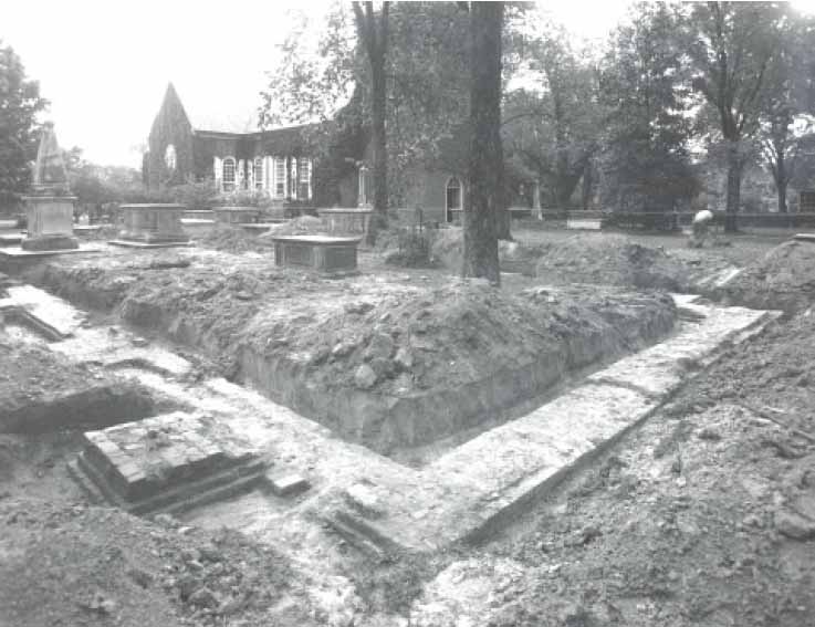 Figure 5. Northwest corner of First Brick Church, 1938.
6
that year, was quite clean, however, suggesting that the backfill from the trench originated from a different source.
Figure 5. Northwest corner of First Brick Church, 1938.
6
that year, was quite clean, however, suggesting that the backfill from the trench originated from a different source.
Prior to the archaeological excavation of 1992, four phases of digging occurred within the area uncovered:
- 1.1938—Church walls exposed.
- 2.1938—Nine-foot-deep trench excavated just west of Ann Frank's tomb. Brass studded coffin encountered.
- 3.1938—Brass-studded coffin exposed.
- 4.1991—Two unauthorized excavations in search of vault.
None of the previous digging (not to be confused with archaeology) was done with any care or thought toward preserving the archaeological record. If any artifacts were recovered, no record of them exists and their location is unknown. The unbridled digging in 1938 caused at least two graves to be desecrated, perhaps more in other areas of the churchyard. Ironically, proper archaeological procedure was known and being carried out by National Park Service archaeologists just eight miles away in Jamestown. The thought of enlisting the help of a professional apparently did not occur to anyone at the time. The damage done to the stratigraphic record in 1938 may have precluded anyone's ever learning significant information regarding the above-ground architectural details of Bruton's First Brick Church.
Archaeological Methods and Procedures
The archaeological methods and procedures used at the First Brick Church were, in many ways, less complex than those ordinarily employed when excavating a seventeenth-century historical site. Most contemporary sites excavated in the Chesapeake region are houselots with associated domestic buildings containing many features such as refuse pits, wells, post holes, and fence lines. Many artifacts and other material such as animal bone, oyster shell, and seeds are usually recovered from such sites. The majority of these domestic sites seem to be located in areas which had been used for agricultural pursuits and were often subjected to hundreds of years of plowing. Historical documentation on these sites can be lacking as well. Such sites present data-collection challenges not encountered at the Brick Church site. The 1683 church site is not domestic in nature, so the features, artifacts, and other material ordinarily accumulated through daily living did not exist. It differed as well in the amount of information available; for example, the exact location of the part of the foundation scheduled for study was known from the 1938 work as was the probable extent of disturbance from that excavation. Also known was much of the church's history, the location of the alleged anomaly, and the mythical location of the supposed vault of Sir Francis Bacon. All of these factors influenced the way the excavation would be conducted, artifacts recovered, and records kept.
Work began by laying out a single 6.0 meter (ca. 20 foot) square excavation unit, making certain that the marker1 for the northwest corner of the church foundations was included within the unit, as were the areas of the illicitly-dug 1991 hole and the location of the suspected anomaly (Figure 6). The position of each of the four corners of the unit was recorded using a laser theodolite and subsequently tied into the town grid used for all Historic Area sites. Excavation was initiated by stripping off a thin layer of sod and topsoil within the unit and beginning a re-excavation of the 1991 hole. The work proceeded stratigraphically, i.e., layers and features were excavated in order of their age, the most recent to the oldest. A Harris Matrix stratigraphic sequence chart (a flow-chart showing the relationships of layers and features to one another) was maintained throughout the entire excavation (Figure 7). This standard method for keeping track of complex stratigraphic relationships is used on virtually all sites excavated by Colonial Williamsburg.
All soil layers and features received context numbers, sequentially as they were encountered, and a Context Record form was completed for each. The "site/area" designation for the site was 21BB. Soil colors were matched with chips displayed on Munsell Soil Color Charts and described in terms of Munsell designations. Munsell soil colors are used by archaeologists and geologists to more objectively describe soil color, avoiding "cookie" color classifications such as "chocolate brown." Separate scale drawings, called "single layer plans" were made for each context (layer or feature) in addition to special detail drawings of the foundations and the child's casket.
8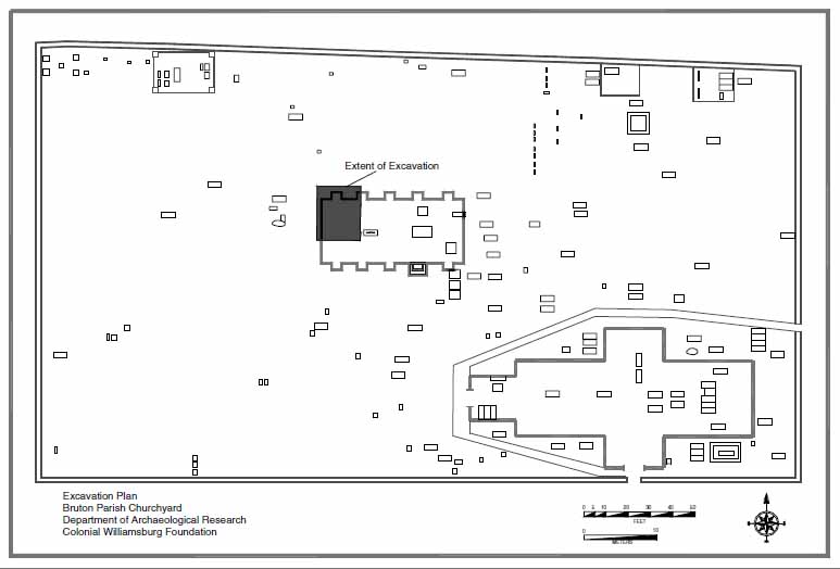 Figure 6. 1992 excavation area.
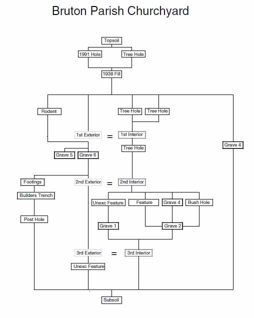 Figure 7. Harris matrix diagram.
Twenty-five percent of the 1991 and 1938 backfill was screened though quarter-inch hardware cloth in order to sample artifacts from these disturbances. All of the soil from layers undisturbed by previous digging was screened thoroughly. Artifacts recovered were placed in polyethylene bags numbered according to the context from which they came. All artifacts were taken to the department laboratory where they were washed and catalogued in the D.A.R. computer system. Window glass and other architecturally-related material was mended and cross-mended. A complete listing of all artifacts recovered can be found in Appendix 1.
Historic Context (from the vestry records)
Bruton Parish was formed in 1674 by the uniting of Marston and Middletown Parishes. By 1678, donations were being accepted from the parishioners towards the building of a new church located at Middle Plantation. This new church, to be constructed of brick, would presumably replace the two wooden(?) churches which had served the formerly separated parishes. Land for the church and churchyard were donated (along with £20 sterling) by prominent Middle Plantation resident John Page (McCabe 1856).
In the following year, 1679, the vestry contracted with George Marable to construct the building for the sum of £350 sterling. Mr. Marable lost the contract, however, when he filed a lawsuit against two of the vestrymen for some now-obscure reason. The construction was delayed until 1681 at which time the vestry contracted with Captain Francis Page to build the church on John Page's donated land. This time the consideration was £150 sterling and 30 pounds of tobacco each year for three years.
The church was completed late in 1683 and dedicated on Epiphany in 1684. The first hint of problems in the construction of the building, which would apparently lead to its early demise, came in the following October when the vestry, feeling the church had been built in an unworkman-like manner, appointed a committee to inspect it. At the same time, a proposal was submitted to the vestry for the construction of a bell tower, an addition that was apparently never realized.
Only ten years after the building was completed, the vestry records reveal that "inside work on ye church ought to be rectified and repaired, it is therefore ordered that the … Churchwardens provide an able man to effect same" (McCabe 1856:594) . In 1702 repairs in "brick and wood" were ordered. The next year craftsmen were hired to build a new pulpit, pews, and raise the floor. This passage may suggest that the floor of the First Brick Church was wooden, as raising it was ordered at the same time as two other projects involving carpentry were contracted.
In 1705 the vestry asked Henry Tyler, a prominent Middle Plantation and Williamsburg resident, to procure carpenters to inspect the church and report to the vestry whether it could be repaired and, if so, how much it would cost. Apparently the repairs were effected, but not well and at too great an expense, as the next year the vestry minutes complain about the cost of the work and that the church was still in bad shape. At that point it ordered 20,000 pounds of tobacco to be levied at the rate of 30 pounds per person, towards the construction of a new church. The First Brick Church of Bruton Parish had served only 23 years.
In 1710 the vestry determined that "…a Church of ye same dimensions of ye old Church will be large enough, and that £500 would be sufficient for building it" (McCabe 1856:605). The House of Burgesses indicated it would pay for pews for the governor, council and house members. With the influx in the number of parishioners increasing dramatically in 1693 with the establishment of William & Mary, and again in 1699 with the moving of the capital from Jamestown to Williamsburg, one may logically assume that the 11 reason for erecting a new church would be to build a larger one to accommodate the new parishioners. This was apparently not the case, since the proposal for a new church was for one the same size. The vestry records seem to indicate that the First Brick Church of Bruton Parish was poorly constructed initially and fell quickly into disrepair. After a little over 30 years of service, the building finally had to be replaced. Considering the present structure has served the parish for over 275 years, the life-span of the earlier building was brief indeed.
In 1716, after the present church was finished, the vestry ordered "that the Churchwardens dispose of all materials belonging to the old church, except the bricks" (McCabe 1856:610). What happened to the brick is not known, but they may have been sold or used in walls and walkways by the church.
Excavation Process
Archaeological excavation in the Bruton Parish Churchyard (CWF designation 21BB) began on the morning of August 18, 1992 with removal of the topsoil and sod within a 6-meter (ca. 20 by 20 foot) square excavation unit. The topsoil, as most in the Williamsburg area, consisted of a dark brown (Munsell color 10YR3/3) sandy loam with considerable organic inclusions. The removal of topsoil and sod facilitated the defining of the two holes dug by Marsha Middleton, Frank Flint, and others in the fall of 1991. Their second hole was totally contained within the first and because a relatively short time had elapsed between events, both were excavated as one context. Heavy rains the week before the project began prevented full excavation of the feature for another few weeks. Water was found at approximately two feet below the surface.
The next procedure was to determine the extent of Marie Bauer Hall's 1938 diggings and to remove this backfill as well as any later disturbances. The 1938 excavation trenches (21BB-10) were defined and the backfill removed from over the brick foundations so they could be photographed and drawn in detail. The remainder of the 1938 backfill was partially excavated in order to define its location. Some areas of the 1938 diggings were expected to be nine feet deep, so complete excavation was delayed until other areas of the unit could be investigated. Standard archaeological procedure would dictate the removal of all the backfill from the 1938 excavations before proceeding to older layers, however, it was felt that leaving very deep holes in the site for several weeks would pose a danger to the crew and other participants as well as increasing the chance of damage from erosion from heavy rains.
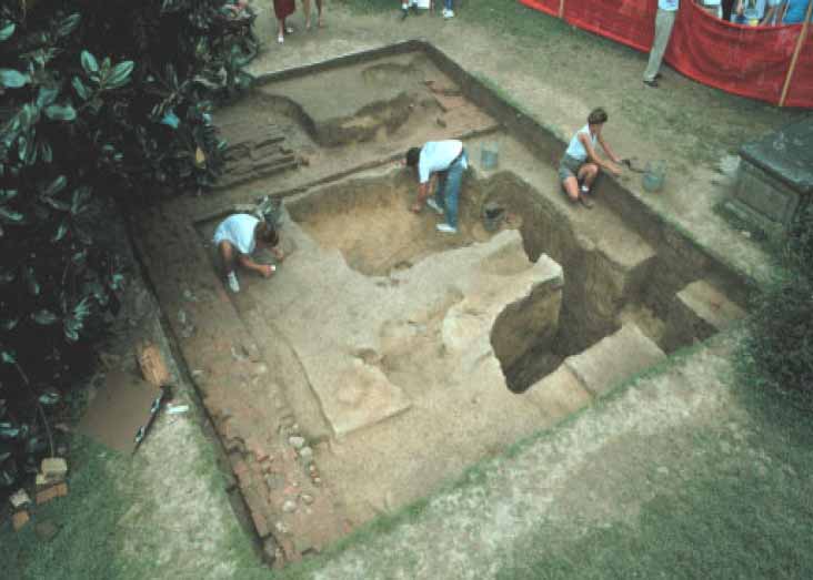 Figure 8. Excavation in progress.
The intact layers within the church foundations undisturbed by the 1938 trenching were addressed at this time. The 1938 trenches, while intrusive, offered a "free look" at the stratigraphy of the undisturbed layers because they cut through them, creating vertical "profiles" of the intact stratigraphy within the interior of the church. This stratigraphy appeared to be a consistent color from just below the topsoil to the subsoil, a distance of about a third of a meter (ca. 13"). Ordinarily, archaeologists excavate same-color soil layers as one layer or context, but since this layer appeared consistent for a foot or more, it was divided into three arbitrary horizontal layers. Each one of these arbitrary layers received its own context designation and was excavated as if it were a distinctly different layer. The division was made because the differences in soil layers, especially in a non-domestic environment, can be quite subtle and not readily recognizable from an initial examination of the soil. If, after excavation and artifact analysis, the arbitrary divisions proved to be a single context, then they could be reassigned a single number. If the layer was not initially divided and proved to be more than one context after examination, it could not be easily separated into its components.
The first arbitrary layer (21BB-12) was a dark greyish brown (10YR4/2) friable sandy clay loam. The terminus post quem of the layer was 1876 (meaning the layer was deposited after that date), based on a chunk of Portland cement recovered from it.
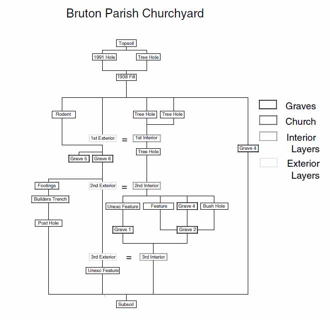 Figure 9. Harris matrix.
The second arbitrary unit (21BB-15) was also a friable sandy clay loam but was olive brown (2.5Y4/4), slightly lighter than 21BB-12. It contained only brick fragments and a roofing tile fragment. The roofing tile may suggest the type of roof treatment used on the 1683 church, or could have been related to an earlier Middle Plantation period nearby structure.
The third and final arbitrary level (21BB-20) rested on sterile subsoil. It was the same color and consistency as the level above, but contained window glass, bottle glass, brick and nails. The concentration of brick in this layer may relate to the destruction of the church during the second decade of the eighteenth century.
Four of the six unmarked graves found during the course of excavation lie within the foundations of the old church (Figure 10). Two, possibly three, of these interments may have taken place while the church was still in use. While visiting the excavations, former Colonial Williamsburg Resident Archaeologist Ivor Noël Hume observed that three of the graves (1, 2, and 3) would have been located in the central nave aisle of the old church, speculating that they may have been dug into the floor of the standing church and contain the remains of "people of consequence." This interpretation is substantiated by the fact that the grave pits of graves 1 and 2 did not become clearly defined until removal of the last arbitrary layer (21BB-20) was excavated. This layer contained what is believed to be destruction debris from the dismantling of the 1683 church. The graves must have been already dug before the church was razed. The Harris Matrix chart maintained during the excavation, illustrates the relative positions of Graves 1 and 2 to the arbitrary layers mentioned. The origin of the third grave, Grave 3, is less clear. The growth and subsequent removal of a tree on the grave obscured its relationship with most of the surrounding stratigraphy. Although located where the central aisle would have been, the grave is not properly oriented with the east-west position of the church walls and other graves.
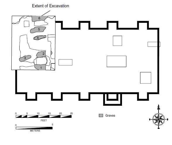 Figure 10. Unmarked graves found within excavation area.
Graves 1 and 2 (Figures 11 and 12) had been cut by the 9-foot-deep north-south trench dug in December of 1938 in search of the equipotential anomaly found by Canadian geophysisist Malumphy at that time. The skeletal remains of femurs belonging to both interments were visible in the western profile of the 1938 trench. The inexperienced diggers in 1938 were apparently unaware they were disturbing graves. The 1991 diggers, also inexperienced and further hampered by digging in the dark, were equally unaware they were disturbing the sides of both graves. Luckily, the later hole was serendipitiously placed between the two graves, not intruding upon the bones in either.
In addition to these two graves and the one found under the tree fill, three other interments were found in the excavation unit. In 1938, the 9-foot-deep, north-south trench struck the bottom edge of a wooden coffin, dislodging a fragment studded with brass tacks. It was apparently at this juncture that the Bruton Parish vestry stopped the excavations. Although not evident from the various accounts of the diggings, the coffin was totally uncovered in 1938. Excavation of a large section of the backfill (in which was found the coffin fragment they displaced) revealed the small, brass-studded coffin (Figure 12). Although the coffin did not appear to have been extensively disturbed by the 1938 excavations, it was almost certainly examined. Apparently no photographs were taken at the time.
These graves (4, 5, and 6) appear to be later than the other three. The brass-studded coffin was identified as eighteenth century by furniture expert Wallace Gusler. Grave 5 cuts through the footing of the First Brick Church and therefore must post-date its destruction.
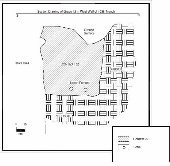 Figure 11. Section drawing of Grave 2.
16
Figure 11. Section drawing of Grave 2.
16
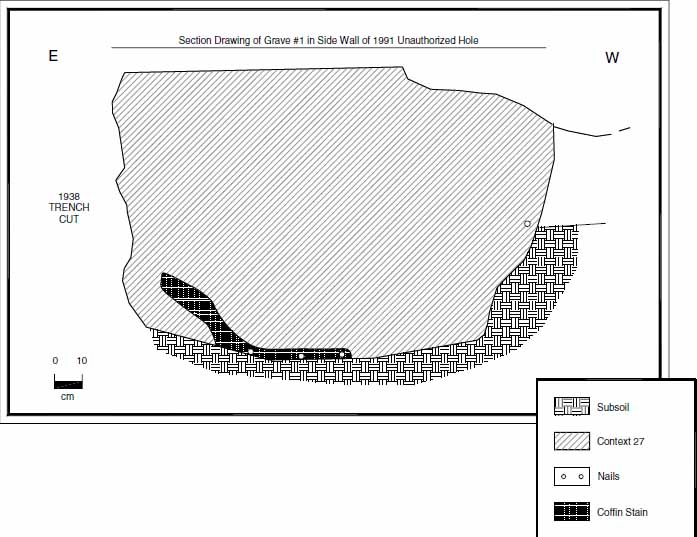 Figure 12. Section drawing of Grave 1.
Grave 6 is outside and north of the church foundations. The outline of its grave shaft became clear above the destruction layer of the old church and is probably not related to it.
Figure 12. Section drawing of Grave 1.
Grave 6 is outside and north of the church foundations. The outline of its grave shaft became clear above the destruction layer of the old church and is probably not related to it.
All of the graves, with the exception of Grave 3 appear to form a north-south line, even though Graves 1 and 2 were probably forgotten before Graves 4, 5, and 6 were dug.
The opportunity to examine an eighteenth-century coffin is not a frequent occurrence. Conservation director and noted authority on eighteenth-century furniture Wallace Gusler carefully examined the coffin remains uncovered after the removal of the 1938 fill. He believes the coffin was made for a sub-adult (it measured 1.7 m [67"] by 0.5 m [20"]) from a family of substance. Similar coffins, covered with wool felt and constructed of yellow pine, were made to order by eighteenth-century furniture craftsmen Benjamin Bucktrout and Anthony Hay, at a cost of approximately five pounds, a substantial sum at the time.
Both the top and side edges of the coffin were studded with brass furniture tacks, spaced about ½ inch apart, chemicals from the decomposition of which served to preserve the wood an inch or more around the nails in all directions. Wood from the remainder of the casket had completely deteriorated, causing the top to collapse onto the remains of the occupant. A 22 cm (8.7") cut was made across the shoulder of the casket in order to expose the collapsed top. It was hoped that the top may have contained a brass
17
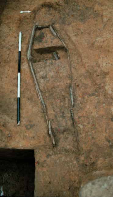 Figure 13. Details of eighteenth-century coffin.
or lead plaque bearing the name or monogram of the occupant, but the top only contained a single line of brass tacks as a simple decoration. After drawing and photographing the coffin, it was immediately backfilled to protect it from exposure to the elements and possible souvenir seekers.
Figure 13. Details of eighteenth-century coffin.
or lead plaque bearing the name or monogram of the occupant, but the top only contained a single line of brass tacks as a simple decoration. After drawing and photographing the coffin, it was immediately backfilled to protect it from exposure to the elements and possible souvenir seekers.
The north side of the excavation area was extended 1.5 m (4.9 feet) in order to open the entire northwest buttress for examination and to expose any area between the buttresses that may not have been disturbed by Marie Bauer Hall or eighteenth-century burials. Intact layers outside the church walls, directly below where a window may have existed, could hold valuable information about the fenestration of the old church.
Only a very small, irregular area covering less than a square meter survived the 1938 digging and the eighteenth-century burials. This layer was divided into two arbitrary levels. The first arbitrary level was designated 21BB-40, consisting of an olive brown (2.5YR4/3) friable sandy clay loam containing creamware, window glass, wine bottle glass, shell, brick, coal, slate, clinker, and a nail. The presence of creamware suggests it was deposited after 1762.
The second layer (21BB-48), between 21BB-40 and subsoil, was identical in the color and texture of the soil, but was similar to the destruction layer (21BB-20) in content. Wine bottle glass, window glass, slate, brick fragments, a ceramic tile, and an unidentified 18 iron fragment were recovered from the layer. Unfortunately, the window glass fragments did not mend into any discernable shape, leaving specifics about the church's window treatment unknown.
All cultural soil layers and features with the exception of the human burials and about 0.3 m (1 foot) of 1938 backfill in the deep trench were excavated within the excavation unit. Backfill from the 1938 trench was excavated to a depth of over 7.0 feet at which point the possibility of collapse made it too dangerous to continue.
After the archaeological excavations were completed, Professor Gerald Johnson and a team of volunteers from William & Mary's geology department hand augered 12 holes, 4 inches in diameter, more than twenty feet below the surface (Figure 14). All of the auger holes revealed natural, undisturbed stratigraphy. A permanent water table was struck at approximately 18 feet.
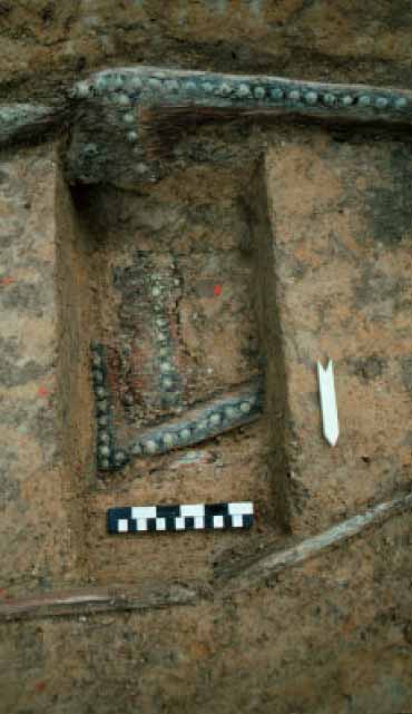 Figure 14. Dr. Gerald Johnson taking an auger sample.
Conclusions
The research plan accepted by the Bruton Parish vestry discussed some of the information it was hoped that the archaeology of a portion of the First Brick Church foundations could provide. Recovery of this information was accomplished whenever possible, but some of the necessary material was simply not available.
- 1.A detailed record of the foundation brickwork, including one full buttress, was made. The scale drawing was also digitized using AutoCAD.
- 2.Archaeology was not able to establish the original floor level which may have provided information on the floor plan, central alley width, pew location, and floor paving material. A concentration of brick fragments contained within the undisturbed layer between topsoil and subsoil probably represents the destruction of the church in the early eighteenth century. As the floor was likely removed before the walls were torn down, this concentration of brick was deposited below the floor level. Insufficient numbers of flooring-related artifacts were recovered to determine the type of floor in the church, although recovery of what appears to be a fragment of purbeck is intriguing. Purbeck is a fossiliferous limestone found in the south of England frequently used for paving. The basement floor of the Governor's Palace was paved with purbeck. As mentioned earlier, however, a passage in the vestry records may hint that the floor was wooden. Unfortunately, archaeological evidence for either treatment is scanty.
- 3.The presence of a gallery and stairway were not confirmed. No post holes that could have supported a gallery were uncovered in the excavation area. If such supports had existed, they may have been obliterated by the 1938 diggings, or the gallery support posts rested directly on the floor rather than being held in the ground below.
- 4.No burial vaults existed, or had ever existed, within the excavation area.
- 5.The brickwork uncovered represented only the footings for the foundation of the First Brick Church and were, as characteristic of footings from the period, not mortared and followed no particular bonding style. Many of the bricks used in the footings were bats, or partial brick, some of which had broken while being fired, as the broken ends were glazed. All of the bricks appear to have been newly made when placed in the footings, but the poorest brick of the lot were used below ground. The footings for the western wall of the church rested on top of the north wall footings, rather than being tied in to them; other than being an unusual construction technique, little else can be inferred from the procedure (Lounsbury, personal communication).
- 6.Six previously unknown graves were found during the course of excavation. At first, five of the six appear to be part of a row of graves dug some time in the eighteenth century, but close examination of the stratigraphic relationships and their positions within the church foundations suggests that two or three of them were
20
probably dug under the church floor while it was in use. Grave 5 was dug though the north wall of the church, apparently long after its location had been forgotten. Since three of the later graves appear to be in a north-south line, it is likely that they had wooden markers which have long-since rotted away.
One of the unmarked graves contained the remains of a brass-studded yellow pine coffin of considerable quality. The deteriorating brass had served to preserve enough of the wood to determine construction techniques used in its manufacture. The coffin was examined on-site by Colonial Williamsburg furniture experts, was drawn in detail, and copiously photographed before being covered. This find was unusual and will add much to the understanding of eighteenth-century casket-making techniques.
- 7.It was firmly established, beyond all reasonable doubt, that "Francis Bacon's Vault" is not and was never located within the area excavated.
- 8.The cause of the remote-sensing anomaly or anomalies was determined through archaeology and geologic testing. According to Dr. Gerald Johnson, one of the anomalies was caused by differential porosity and permeability of the soil in the backfill of the 1938 excavations. The other anomaly was the result of differential dissolution of fossil shells in an ancient Chesapeake Bay bottom deposit 14 feet below the surface called the Yorktown Formation. A trough-shaped zone of leached or partially leached (oxidized) calcium carbonate in the Yorktown deposit extended from the southwest corner of the excavation area, diagonally to the north-center and then to the northwest corner. This trough is roughly the same shape as the anomaly found by Bevan in the mid-1980's (Gerald Johnson, personal communication, 23 Nov 1992).
Further archaeology at Bruton Parish's First Brick Church site is recommended. The footings should be uncovered in their entirety and undisturbed soil layers and features relating to the construction, use, and destruction of the church should be found and carefully excavated. The northwest corner of the foundations was the most intensively disturbed in 1938 since it was the area of Malumphy's anomaly and the suspected location of Bacon's vault. Hopefully, other areas of the church will not have been quite as thoroughly excavated, leaving layers, features, and artifacts which would undoubtedly shed more light on the above-ground appearance of the church and add immensely to the overall knowledge of seventeenth century ecclesiastical structure.
The discovery of six previously unknown graves in such a small excavation area has pointedly illustrated that the Bruton Parish churchyard is indeed filled to capacity. Further excavation will surely uncover many more forgotten graves. An archaeological excavation associated with the First Brick Church would provide an excellent opportunity to examine and test established remote-sensing methods such as ground-penetrating radar, electromagnetic induction, magnetic, and resistivity and new sensing apparatuses designed to locate small features such as graves. Fine tuning such equipment would make it an even more valuable tool in locating graves in highway right-of-ways and construction sites where unmarked graves are not so well protected.
21The amount of publicity generated by the three-week excavation because of the alleged presence of the mystical "Bacon's Vault" succeeded in stirring a level of interest in local archaeology never before realized. Articles on Bruton Heights archaeology, the 1634 palisade, and the lead coffins discovered at St. Mary's City, Maryland have appeared in local newspapers since the end of the Bruton Parish excavations. Logically, the more often that interesting archaeology is presented to the general public, the more aware some will become about preserving our fragile past.
References
- 1991
- Comments on Paul Hudson's October 15, 1991 memorandum to the rector of Bruton Parish regarding "What Will Archaeologists Find within the Foundations of the 1683-1715 Bruton Parish Church?" Manuscript on file at the Department of Archaeological Research, Colonial Williamsburg Foundation, Williamsburg, VA.
- 1939
- Foundations Unearthed. Veritat Foundation, Los Angeles.
- 1987
- A Geophysical Search for the Bacon Vault. Unpublished report on file in the Department of Archaeological Research, Colonial Williamsburg, Williamsburg, VA.
- 1992
- Archaeological Answers to Architectural Questions Concerning the First Brick Church at Middle Plantation. Memo to Marley R. Brown III, September 22, 1991. On file at the Department of Archaeological Research, The Colonial Williamsburg Foundation, Williamsburg, VA.
- 1856
- Sketches of Bruton Parish, Williamsburg, Virginia. In American Eccesiastical History, Article VII. Colonial Churches in Virginia.
- 1992
- Chapels, Vaults, and Coffins: Recent Archaeological Discoveries at St. Mary's City. Presentation given at the Williamsburg Regional Library, August 20, 1992.
Appendix 1.
Artifact Inventory
As mentioned in the "Archaeological Methods and Procedures" section of this report, artifacts recovered from a church site carry with them different connotations because of the context in which they finally became deposited in the ground. Artifacts usually associated with domestic activities, i.e., fragments of ceramics, bottles, oyster shell, etc. generally have little interpretive meaning on a non-domestic site. In the case of Bruton Parish's First Brick Church, those artifacts considered architectural in nature such as nails, brick, paving stone, roofing tile, and window glass, are vitally important to the interpretation of the structure. Such artifacts are important because they can give archaeologists and architectural historians a better idea what the church may have looked like above the ground level. By careful excavation of the area just outside the walls of the brick chapel at St. Mary's City, archaeologists have been able to gather enough information about the seventeenth-century Catholic church that plans are being made to reconstruct the building (Miller 1992).
Unfortunately, the architectural artifacts recovered at Bruton Parish have not been so informative, probably due to the considerable destruction of soil layers pertaining to the construction and demolition of the old church by vault seekers in 1938. Other areas of the church which may not have been so intensively dug at that time, could hold answers to questions about the old church's architectural details and interior burials.
The following pages list the artifacts recovered from the 1992 excavations. They are grouped according to the layer (context) in which they were found along with a brief description of each context, its number, and the date of the latest artifact in the group (TPQ). The artifact in each context containing an '*' is the artifact upon which the TPQ is based.
Note: Inventory is printed from the Re:discovery cataloguing program used by Colonial Williamsburg, manufactured and sold by Re:discovery Software, Charlottesville, Virginia.
Brief explanation of terms:
- Context No.
- Arbitrary designation for a particular deposit (layer or feature), consisting of a four-digit "site/area" designation and a five-digit context designation. The site/area for this project is "21BB."
- TPQ
- "Date after which" the layer or feature was deposited, based on the artifact with the latest initial manufacture date. Deposits without a diagnostic artifact have the designation "NDA," or no date available.
- Listing
- The individual artifact listing includes the catalog "line designation," followed by the number of fragments or pieces, followed by the description.
| AA | 1 | REFINED EARTHEN, PEARLWARE, FRAGMENT, PRINTED UNDER, BLACK |
| AB | 1 | STONEWARE, FULHAM SW, FRAGMENT |
| AC | 2 | GLASS, FRAGMENT, WINDOW GLASS |
| AD | 1 | GLASS, CLRLESS NON-LD, FRAGMENT, CONTAINER, * |
| AE | 2 | IRON, NAIL, FRAGMENT |
| AF | 1 | IRON, UNID HARDWARE |
| AA | 4 | REFINED EARTHEN, CREAMWARE, FRAGMENT, UNDECORATED |
| AB | 1 | REFINED EARTHEN, PEARLWARE, FRAGMENT, UNDECORATED |
| AC | 1 | REFINED EARTHEN, PEARLWARE, FRAGMENT, PAINTED UNDER, POLYCHROME |
| AD | 2 | REFINED EARTHEN, PEARLWARE, FRAGMENT, PAINTED UNDER, BLUE |
| AE | 1 | REFINED EARTHEN, WHITEWARE, FRAGMENT, PRINTED UNDER, BLUE |
| AF | 2 | REFINED EARTHEN, WHITEWARE, FRAGMENT, UNDECORATED |
| AG | 4 | REFINED EARTHEN, YELLOW WARE, FRAGMENT, UNDECORATED |
| AH | 2 | STONEWARE, WH SALT-GLAZED, FRAGMENT |
| AI | 1 | STONEWARE, WH SALT-GLAZED, FRAGMENT, DOT/DIAPER/BASK |
| AJ | 38 | GLASS, FRAGMENT, WINDOW GLASS |
| AK | 19 | GLASS, FRAGMENT, WINE BOTTLE |
| AL | 2 | GLASS, COLORED, FRAGMENT, CONTAINER, AQUA |
| AM | 2 | GLASS, COLORED, FRAGMENT, CONTAINER, WHITE |
| AN | 2 | GLASS, COLORED, FRAGMENT, CONTAINER, GREEN |
| AO | 1 | GLASS, CLRLESS LEAD, FRAGMENT, TABLE GLASS |
| AP | 5 | GLASS, CLRLESS NON-LD, FRAGMENT, CONTAINER |
| AQ | 2 | GLASS, CLRLESS NON-LD, FRAGMENT, CONTAINER, BURNED |
| AR | 1 | GLASS, CLRLESS NON-LD, FRAGMENT, CONTAINER, MOLD BLOWN |
| AS | 2 | GLASS, CLRLESS NON-LD, FRAGMENT, CONTAINER, OTHER MOLD DEC |
| AT | 1 | GLASS, CLRLESS NON-LD, FRAGMENT, LAMP CHIMNEY, MACHINE-MADE |
| AU | 1 | GLASS, CLRLESS NON-LD, FRAGMENT, CONTAINER, LETTERING/NUMB, '…PRIE…ND, V' |
| AV | 1 | GLASS, CLRLESS NON-LD, FRAGMENT, PHARMACEUTICAL, LETTERING/NUMB, '…CK…', MENDS WITH AW |
| AW | 1 | GLASS, CLRLESS NON-LD, FRAGMENT, PHARMACEUTICAL, MOLD BLOWN, LETTERING/NUMB, '…LEN…', MENDS WITH AV AND AX |
| AX | 1 | GLASS, CLRLESS NON-LD, FRAGMENT, PHARMACEUTICAL, MOLD BLOWN, LETTERING/NUMB, 'DR. KING'S NEW LIFE PILLS..' MENDS W/AW |
| AY | 1 | STONEWARE, NOTTINGHAM SW, FRAGMENT, RUSTICATED |
| AZ | 1 | CERAMIC, TOBACCO PIPE, IMPORTED, STEM |
| BA | 1 | GLASS, COLORED, FRAGMENT, CONTAINER, MOLD BLOWN, BROWN |
| BB | 1 | GLASS, COLORED, FRAGMENT, CONTAINER, OWEN'S SCAR, BROWN |
| BC | 1 | PLASTIC, FRAGMENT, AQUA |
| BD | 1 | GLASS, LIGHT BULB, FRAGMENT, WITH WIRE |
| BE | 1 | BONE, FAUNAL SPECIMEF |
| BF | 3 | COPPER ALLOY, COIN, DATED, * 1989, 1983 AND 1979, U.S. PENNIES |
| BG | 1 | SILVER, COIN, DATED, 17?5 SPANISH 'CAROLUS III DEI GRATIA…' |
| BH | 1 | COPPER ALLOY, BUTTON, TWO PIECE, HEAD/TOP, WITH IRON INSIDE, STAG'S HEAD DESIGN |
| BI | 9 | COAL, COAL |
| BJ | 3 | STONE, STONE, ARCHITECTURAL |
| BK | 1 | SLAG, SLAG/CLINKER |
| BL | 3 | SHELL, SHELL |
| 25 | ||
| BM | 1 | CEMENT, CEMENT, PORTLAND |
| BO | 4 | BRICK, BRICKETAGE |
| BP | 8 | CERAMIC, FRAGMENT |
| BQ | 4 | CERAMIC, FRAGMENT, PAVING TILE, FLOORING TILE |
| BR | 1 | CERAMIC, FRAGMENT, PAVING TILE, LETTERING/NUMB, FLOORING TILE, '…LADON CO…GO…' |
| BS | 4 | CERAMIC, PIPE, SEWER PIPE |
| BT | 4 | STONE, STONE, UNWORKED |
| BU | 2 | IRON, NAIL, OVER 4 IN, WIRE |
| BV | 5 | IRON, NAIL, 2 TO 4 IN, WIRE |
| BW | 6 | IRON, NAIL, LESS THAN 2 IN, WROUGHT/FORGED |
| BX | 1 | IRON, NAIL, LESS THAN 2 IN, WIRE |
| BY | 6 | IRON, NAIL, FRAGMENT |
| BZ | 1 | IRON, CUTLERY, POSSIBLE SKEWER |
| CA | 4 | IRON, UNID HARDWARE |
| AA | 1 | REFINED EARTHEN, CREAMWARE, FRAGMENT, UNDECORATED |
| AB | 1 | STONEWARE, WH SALT-GLAZED, FRAGMENT, SCRATCH/FILL, BLUE |
| AC | 1 | GLASS, CLRLESS NON-LD, FRAGMENT, CONTAINER, MOLD BLOWN |
| AD | 2 | CEMENT, CEMENT |
| AE | 1 | GLASS, LIGHT BULB, * WITH COPPER ALLOY BASE AND WIRE |
| AF | 5 | GLASS, LIGHT BULB, FRAGMENT |
| AG | 1 | IRON, UNID HARDWARE, ROLLED/SHEET |
| AH | 2 | IRON, NAIL, FRAGMENT |
| AI | 1 | IRON, PIPE |
| AA | 12 | BRICK, BRICKETAGE |
| AB | 1 | GLASS, FRAGMENT, WINDOW GLASS |
| AC | 1 | GLASS, CLRLESS NON-LD, FRAGMENT, CONTAINER |
| AD | 3 | COAL, COAL |
| AE | 2 | SHELL, SHELL |
| AF | 1 | CEMENT, CEMENT, PORTLAND, * |
| AG | 1 | IRON, NAIL, LESS THAN 2 IN, WROUGHT/FORGED |
| AH | 2 | IRON, NAIL, FRAGMENT |
| AA | 1 | REFINED EARTHEN, CREAMWARE, FRAGMENT, UNDECORATED, * |
| AB | 3 | GLASS, FRAGMENT, WINDOW GLASS |
| AC | 3 | GLASS, FRAGMENT, WINE BOTTLE |
| AD | 1 | COAL, COAL |
| AA | 1 | PORCELAIN, CH PORCELAIN, FRAGMENT, PAINTED OVER, BLACK |
| AB | 1 | COARSE EARTHENW, RED-BOD SLIP, FRAGMENT, POSSIBLY PHILADELPHIA SLIPWARE |
| AC | 4 | GLASS, FRAGMENT, WINDOW GLASS |
| AD | 2 | COAL, COAL |
| AE | 1 | SHELL, SHELL |
| AF | 1 | PLASTIC, FRAGMENT, PINK, * DISPOSIBLE PLASTIC BANDAGE |
| AG | 2 | ALUMINUM, FRAGMENT, ALUMINUM FOIL |
| AH | 2 | IRON, NAIL, 2 TO 4 IN, WROUGHT/FORGED |
| AI | 4 | IRON, NAIL, FRAGMENT |
| AJ | 5 | BRICK, BRICKETAGE |
| AK | 1 | BURNED CLAY, FRAGMENT |
| AA | 1 | COAL, COAL |
| AB | 9 | SHELL, SHELL, TWO NOT OYSTER |
| AC | 15 | BONE, FAUNAL SPECIMEN |
| AD | 1 | REFINED EARTHEN, WHITEWARE, FRAGMENT, UNDECORATED |
| AE | 3 | GLASS, FRAGMENT, WINDOW GLASS |
| AF | 2 | BRICK, BRICKETAGE |
| AG | 2 | GLASS, FRAGMENT, WINE BOTTLE |
| AH | 1 | GLASS, CLRLESS NON-LD, FRAGMENT, CONTAINER, * |
| AI | 1 | STONE, STONE, UNWORKED |
| AJ | 1 | MARL, MARL |
| AK | 1 | IRON, WIRE |
| AL | 1 | IRON, UNID HARDWARE |
| AM | 2 | IRON, NAIL, FRAGMENT |
| AA | 1 | REFINED EARTHEN, PEARLWARE, FRAGMENT, ANNULAR, BROWN |
| AB | 1 | REFINED EARTHEN, CREAMWARE, FRAGMENT, UNDECORATED |
| AC | 2 | REFINED EARTHEN, PEARLWARE, FRAGMENT, UNDECORATED |
| AD | 1 | REFINED EARTHEN, PEARLWARE, FRAGMENT, PAINTED UNDER, BLUE |
| AE | 1 | REFINED EARTHEN, PEARLWARE, FRAGMENT, PRINTED UNDER, BLUE |
| AF | 1 | REFINED EARTHEN, WHITEWARE, FRAGMENT, UNDECORATED |
| AG | 1 | COARSE EARTHENW, RED-BOD SLIP, FRAGMENT, POSSIBLY PHILADELPHIA SLIPWARE |
| AH | 1 | COARSE EARTHENW, COARSEWARE, FRAGMENT, LEAD GLAZE |
| AI | 1 | COARSE EARTHENW, YORKTOWN-TYPE, FRAGMENT |
| AJ | 2 | STONEWARE, WH SALT-GLAZED, FRAGMENT |
| AK | 1 | STONEWARE, FULHAM SW, FRAGMENT |
| AL | 1 | STONEWARE, AMER STONEWARE, FRAGMENT |
| AM | 1 | CERAMIC, TOBACCO PIPE, IMPORTED, STEM |
| AN | 1 | CERAMIC, TOBACCO PIPE, IMPORTED, BOWL |
| AO | 1 | GLASS, CLRLESS NON-LD, FRAGMENT, CONTAINER, MACHINE-MADE, FINISH, * |
| AP | 1 | GLASS, CLRLESS NON-LD, FRAGMENT, LIQUOR BOTTLE, MACHINE-MADE |
| AQ | 4 | GLASS, CLRLESS NON-LD, FRAGMENT, CONTAINER, MAKER'S MARK, PIECES MEND, TRADEMARK DG CO. OR GD CO. |
| AR | 1 | GLASS, CLRLESS NON-LD, FRAGMENT, CONTAINER, LETTERING/NUMB, '…EDE…ORRE…' |
| AS | 1 | GLASS, CLRLESS NON-LD, FRAGMENT, CONTAINER, LETTERING/NUMB, '…LE…BOTTLE' |
| AT | 1 | GLASS, CLRLESS NON-LD, FRAGMENT, CONTAINER, LETTERING/NUMB, '…ULL…RA…' |
| AU | 1 | GLASS, CLRLESS NON-LD, FRAGMENT, CONTAINER, LETTERING/NUMB, '…INT…' |
| AV | 1 | GLASS, CLRLESS NON-LD, FRAGMENT, LIQUOR BOTTLE, LETTERING/NUMB, '…LAW FOR…USE OF THIS…' |
| AW | 1 | GLASS, CLRLESS NON-LD, FRAGMENT, CONTAINER, MOLD BLOWN, BASE, MENDS WITH AX, LINER TO THERMOS |
| AX | 1 | GLASS, CLRLESS NON-LD, FRAGMENT, MOLD BLOWN, MENDS WITH AW, LINER TO THERMOS |
| AY | 18 | GLASS, CLRLESS NON-LD, FRAGMENT, CONTAINER |
| AZ | 2 | GLASS, LIGHT BULB, FRAGMENT |
| BA | 1 | GLASS, CLRLESS NON-LD, FRAGMENT, LAMP CHIMNEY, HAND TOOLED FIN |
| BB | 1 | GLASS, MANG SOLARIZED, FRAGMENT, CONTAINER |
| BC | 1 | GLASS, CLRLESS LEAD, FRAGMENT, TABLE GLASS |
| 27 | ||
| BD | 38 | GLASS, FRAGMENT, WINDOW GLASS |
| BE | 2 | GLASS, COLORED, FRAGMENT, CONTAINER, GREEN |
| BF | 4 | GLASS, COLORED, FRAGMENT, PHARMACEUTICAL, AQUA |
| BG | 1 | GLASS, COLORED, FRAGMENT, PHARMACEUTICAL, AQUA, LETTERING/NUMB, '…RCE, M…', MENDS WITH BH |
| BH | 1 | GLASS, COLORED, FRAGMENT, PHARMACEUTICAL, AQUA, LETTERING/NUMB, '…D.', MENDS WITH BG |
| BI | 4 | GLASS, COLORED, FRAGMENT, CONTAINER, WHITE |
| BJ | 26 | GLASS, FRAGMENT, WINE BOTTLE |
| BK | 1 | GLASS, COLORED, BOTTLE, LIQUOR BOTTLE, OTHER MOLD DEC, OWEN'S SCAR, BROWN, COMPLETE, MAKER'S MARK, MARK W/ 'FEDERAL LAW…', W/ IRON CAP |
| BL | 2 | GLASS, COLORED, FRAGMENT, LIQUOR BOTTLE, OTHER MOLD DEC, OWEN'S SCAR, BROWN, BASE, MAKER'S MARK, MARK W/ 'ONE PINT' AND 'D-201 72 N 7' |
| BM | 1 | GLASS, COLORED, FRAGMENT, LIQUOR BOTTLE, CONTIN THREAD, BROWN, FINISH, LETTERING/NUMB, '…LAW FOR…USE OF' WITH IRON CAP |
| BN | 1 | GLASS, COLORED, FRAGMENT, LIQUOR BOTTLE, CONTIN THREAD, BROWN, FINISH |
| BO | 1 | GLASS, COLORED, FRAGMENT, LIQUOR BOTTLE, OTHER MOLD DEC, OWEN'S SCAR, BROWN, BASE, LETTERING/NUMB, 'ONE PINT' AND '…201…N 7'MENDS W/BP |
| BP | 1 | GLASS, COLORED, FRAGMENT, LIQUOR BOTTLE, OTHER MOLD DEC, OWEN'S SCAR, BROWN, LETTERING/NUMB, 'D…7…', MENDS WITH BO |
| BQ | 1 | GLASS, COLORED, FRAGMENT, LIQUOR BOTTLE, OTHER MOLD DEC, BROWN, LETTERING/NUMB, '…RBIDS SA…THIS BOTTLE' |
| BR | 1 | GLASS, COLORED, FRAGMENT, LIQUOR BOTTLE, BROWN, LETTERING/NUMB, '…INT' |
| BS | 6 | GLASS, COLORED, FRAGMENT, LIQUOR BOTTLE, OTHER MOLD DEC, MACHINE-MADE, BROWN, MAKER'S MARK, TRADEMARK OF A MAN PLAYING POLO |
| BT | 17 | GLASS, COLORED, FRAGMENT, LIQUOR BOTTLE, OTHER MOLD DEC, MACHINE-MADE, BROWN |
| BU | 10 | GLASS, COLORED, FRAGMENT, LIQUOR BOTTLE, MACHINE-MADE, BROWN |
| BV | 9 | BONE, FAUNAL SPECIMEN |
| BW | 17 | SHELL, SHELL |
| BX | 1 | WOOD, COFFIN, FRAGMENT, PAINTED, WITH SIX COPPER ALLOY TACKS |
| BY | 1 | COPPER ALLOY, UPHOLSTERY TACK, COFFIN TACK |
| BZ | 25 | COAL, COAL |
| CA | 10 | CHARCOAL, CHARCOAL |
| CB | 1 | GLASS, LIGHT BULB, WITH COPPER ALLOY BASE AND WIRES |
| CC | 5 | RUBBER, FRAGMENT, BLACK |
| CD | 6 | PAPER, FRAGMENT, COATED WITH METALLIC FOIL AND PRINTED ON |
| CE | 1 | PAPER, FRAGMENT, LETTERING/NUMB, '…AZ…INGHOU…' |
| CF | 11 | PAPER, FRAGMENT, TAR PAPER |
| CG | 11 | STONE, STONE, UNWORKED |
| CH | 2 | STONE, STONE, UNWORKED, WITH CEMENT |
| CI | 31 | BRICK, BRICKETAGE |
| CJ | 1 | BRICK, BRICK |
| CK | 8 | STONE, STONE, ARCHITECTURAL |
| CM | 4 | OTHER ORGANIC, CORAL, FOSSILIZED |
| CN | 2 | SLAG, SLAG/CLINKER |
| CO | 1 | MORTAR, MORTAR, SHELL |
| CP | 2 | CEMENT, CEMENT |
| CR | 1 | MINERAL, FRAGMENT, WITH IMPRESSIONS |
| CS | 1 | MINERAL, FRAGMENT |
| CT | 3 | CERAMIC, PIPE, SEWER PIPE |
| 28 | ||
| CU | 1 | CERAMIC, FRAGMENT, PAVING TILE, LETTERING/NUMB, '…TIL…', FLOORING TILE |
| CV | 1 | CERAMIC, FRAGMENT, PAVING TILE, FLOORING TILE |
| CW | 12 | CERAMIC, FRAGMENT |
| CX | 25 | IRON, NAIL, 2 TO 4 IN, WROUGHT/FORGED, MANY WITH WOOD STILL ADHERING TO THEM |
| CY | 8 | IRON, NAIL, LESS THAN 2 IN, WROUGHT/FORGED, ONE WITH WOOD STILL ADHERING TO IT |
| CZ | 3 | IRON, NAIL, 2 TO 4 IN, CUT, ONE WITH WOOD STILL ADHERING TO IT |
| DA | 1 | IRON, NAIL, LESS THAN 2 IN, CUT |
| DB | 1 | IRON, NAIL, OVER 4 IN, WIRE |
| DC | 6 | IRON, NAIL, 2 TO 4 IN, WIRE |
| DD | 1 | IRON, NAIL, LESS THAN 2 IN, WIRE |
| DE | 1 | IRON, SCREW |
| DF | 31 | IRON, NAIL, FRAGMENT |
| DG | 1 | IRON, UNID HARDWARE, ROLLED/SHEET, LARGE SHEET |
| DH | 1 | IRON, UNID HARDWARE, ROLLED/SHEET, FOLDED |
| DI | 3 | IRON, UNID HARDWARE |
| DK | 1 | PORCELAIN, DOLL PART |
| AA | 1 | REFINED EARTHEN, PEARLWARE, FRAGMENT, PAINTED UNDER, BLUE |
| AB | 32 | GLASS, FRAGMENT, WINDOW GLASS |
| AC | 8 | GLASS, FRAGMENT, WINE BOTTLE |
| AD | 1 | CERAMIC, TOBACCO PIPE, DOMESTIC, STEM |
| AE | 1 | BONE, FAUNAL SPECIMEN |
| AF | 2 | COAL, COAL |
| AG | 7 | SHELL, SHELL |
| AH | 8 | BRICK, BRICKETAGE |
| AI | 1 | CEMENT, CEMENT, PORTLAND, * |
| AJ | 2 | PAPER, FRAGMENT |
| AK | 3 | IRON, NAIL, 2 TO 4 IN, WROUGHT/FORGED |
| AL | 2 | IRON, NAIL, 2 TO 4 IN, CUT |
| AM | 7 | IRON, NAIL, FRAGMENT |
| AM | 1 | OTHER ORGANIC, CORAL |
| AO | 1 | GLASS, COLORED, FRAGMENT, CONTAINER, AQUA |
| AP | 1 | GLASS, CLRLESS LEAD, FRAGMENT, TABLE GLASS |
| AA | 3 | REFINED EARTHEN, WHITEWARE, FRAGMENT, PRINTED UNDER, BLUE |
| AB | 1 | GLASS, CLRLESS LEAD, FRAGMENT, LAMP CHIMNEY, HAND TOOLED FIN, * |
| AC | 1 | IRON, NAIL, FRAGMENT |
| AD | 2 | GLASS, FRAGMENT, WINDOW GLASS |
| AE | 1 | COAL, COAL |
| AF | 2 | CHARCOAL, CHARCOAL |
| AG | 1 | GLASS, CLRLESS NON-LD, FRAGMENT, CONTAINER |
| AH | 1 | SHELL, SHELL |
| AI | 1 | QUARTZITE, HAFTED BIFACE, MORROW MOUNTAIN, COMPLETE, MORROW MOUNTAIN II |
| AJ | 1 | CERAMIC, PIPE, SEWER PIPE |
| AK | 1 | EARTHENWARE, DELFTWARE ENG, FRAGMENT, MISSING GLAZE |
| AL | 1 | IRON, SPIKE, WROUGHT/FORGED |
| AA | 1 | CERAMIC, FRAGMENT, ROOFING TILE |
| AB | 14 | GLASS, FRAGMENT, WINDOW GLASS |
| 29 | ||
| AC | 3 | SHELL, SHELL |
| AD | 1 | GLASS, FRAGMENT, WINE BOTTLE |
| AE | 1 | EARTHENWARE, DELFTWARE ENG, FRAGMENT, MISSING GLAZE |
| AF | 1 | GREY CHERT, STONE, UNWORKED |
| AG | 2 | COAL, COAL |
| AH | 1 | BRICK, BRICKETAGE |
| AI | 4 | IRON, NAIL, 2 TO 4 IN, WROUGHT/FORGED |
| AJ | 2 | IRON, NAIL, FRAGMENT |
| AK | 1 | LEAD, CASTING WASTE |
| AL | 1 | LEAD, UNID HARDWARE, IDENTIFICATION TENTATIVE |
| AA | 5 | GLASS, FRAGMENT, WINDOW GLASS |
| AB | 8 | COAL, COAL |
| AC | 1 | BRICK, BRICKETAGE |
| AD | 3 | SLAG, SLAG/CLINKER |
| AE | 2 | CHARCOAL, CHARCOAL |
| AF | 1 | MINERAL, FRAGMENT |
| AG | 2 | IRON, NAIL, 2 TO 4 IN, WROUGHT/FORGED |
| AH | 4 | IRON, NAIL, FRAGMENT |
| AA | 8 | BRICK, BRICKETAGE |
| AA | 1 | OTHER ORGANIC, SOIL SAMPLE |
| AB | 1 | GLASS, FRAGMENT, WINDOW GLASS |
| AC | 1 | GLASS, CLRLESS NON-LD, FRAGMENT, CONTAINER, * |
| AD | 1 | OTHER ORGANIC, CORAL, FOSSILIZED |
| AE | 39 | BRICK, BRICKETAGE |
| AF | 1 | BRICK, BRICK BAT |
| AG | 1 | IRON, NAIL, 2 TO 4 IN, WROUGHT/FORGED |
| AH | 2 | IRON, NAIL, FRAGMENT |
| AI | 1 | STONE, STONE, UNWORKED |
| AJ | 1 | GLASS, COLORED, FRAGMENT, CONTAINER, GREEN |
| AA | 2 | BRICK, BRICKETAGE |
| AA | 2 | GLASS, FRAGMENT, WINDOW GLASS |
| AB | 3 | BONE, FAUNAL SPECIMEN |
| AC | 1 | SHELL, SHELL |
| AD | 2 | IRON, NAIL, FRAGMENT |
| AE | 1 | LIMESTONE, STONE, ARCHITECTURAL, FOSSILIFEROUS LIMESTONE |
| AF | 1 | BRICK, BRICKETAGE |
| AG | 1 | GLASS, CLRLESS NON-LD, FRAGMENT, CONTAINER |
| AA | 2 | WOOD, COFFIN, FRAGMENT, PAINTED, WITH SEVEN BRASS TACKS |
| AA | 2 | COAL, COAL |
| AB | 1 | COPPER ALLOY, UPHOLSTERY TACK, COFFIN TACK |
| AC | 2 | QUARTZITE, DEBITAGE, FLAKE FRAG/SHAT, 1-74% CORTEX |
| AA | 9 | REFINED EARTHEN, CREAMWARE, FRAGMENT, UNDECORATED, * |
| AB | 2 | GLASS, FRAGMENT, WINDOW GLASS |
| AC | 1 | GLASS, FRAGMENT, WINE BOTTLE |
| AD | 2 | SHELL, SHELL |
| AE | 5 | BRICK, BRICKETAGE |
| AF | 2 | COAL, COAL |
| AG | 1 | STONE, STONE, ARCHITECTURAL |
| AH | 1 | SLAG, SLAG/CLINKER |
| AI | 1 | IRON, NAIL, LESS THAN 2 IN, WROUGHT/FORGED |
| AA | 1 | GLASS, FRAGMENT, WINE BOTTLE |
| AB | 2 | GLASS, FRAGMENT, WINDOW GLASS |
| AC | 1 | GLASS, COLORED, FRAGMENT, TABLE GLASS, AQUA |
| AD | 5 | CHARCOAL, CHARCOAL |
| AE | 1 | STONE, STONE, ARCHITECTURAL |
| AF | 1 | SHELL, SHELL, NOT OYSTER |
| AG | 3 | OTHER ORGANIC, CORAL, FOSSILIZED |
| AH | 13 | BRICK, BRICKETAGE |
| AI | 1 | CERAMIC, FRAGMENT |
| AJ | 1 | IRON, UNID HARDWARE, CAST |
| AK | 1 | IRON, NAIL, LESS THAN 2 IN, WROUGHT/FORGED |